|
|
For seven years, our personnel have conducted geochemical analyses and accurately predicted water quality and reclamation impacts for various mining projects. Through this experience we have gained significant insight into the technical aspects of permitting major hard rock mines in highly sensitive environments.
In support of the operator’s Aquifer Protection Permit application, our personnel, then under the direction of another engineering firm, completed large-scale, geochemical evaluations of the surface and underground mine materials for a large underground copper mine in Arizona.
Materials characterization techniques for both studies included petrographic observations (Figure 1), x-ray diffraction, static testing, partial digestion analyses, and column leachate extractions.
Previous water monitoring had included surface sites around the tailings and waste rock facilities and nested monitoring wells adjacent to the tailings piles. Additional water sampling sites included in this study were located deep within the underground workings. Surface and ground water quality data were compiled and reviewed.
The surface evaluation was conducted to predict future water quality and impacts to revegetation associated with decommissioning and reclaiming these large tailings facilities.
Results indicated that tailings had not acidified to depths greater than 2 meters. Water quality in the deeper tailings and underneath the tailing piles was relatively unimpacted when compared to surface tailings pore water quality.
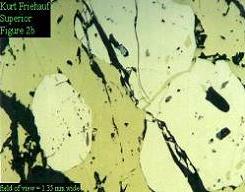
Figure 1. Reflected plane polarized light photomicrograph of advanced chalcopyrite flooding in C-bed ore, Arizona
The underground evaluation was conducted to characterize the existing mine water quality and to predict impacts as a result of flooding this very large, very deep, underground copper mine. The underground mine water was sampled and analyzed. Materials from stopes and tailings backfill were characterized.
Interpretation of water quality data indicated that the underground mine water was not greatly impacted. This due to the operator’s significant ability in engineering the underground workings so that water was diverted from the minesite. Furthermore, qualitative analysis suggested that, when the underground workings were flooded, the overlaying carbonate-dominant lithology would provide sufficient buffering capacity to the hydrologic system to maintain a circum-neutral pH. Recent water quality information from the minesite has corroborated the previous modeling results.
The New World Mining District is located near Cooke City, Montana just north of Yellowstone National Park. In support of the mining company’s mining permit application and working with the State of Montana, the company administered oversight for the extensive, bench-scale geochemical studies.
These studies implemented an array of techniques to characterize ore, waste rock, simulated tailings, and construction and foundation materials. Select rock samples were screened using static testing and submitted for subsequent petrographic and whole rock analysis, and humidity cell and bottle-roll leachate extractions.
In addition, extensive geologic data provided by the U.S. Geological Survey were compiled and interpreted (Figure 2). Site-specific water quality information from adits, surface monitoring sites, and monitoring wells was gathered to characterize background conditions within the immediate area of proposed mining. These data correlated well with local water quality information compiled by the USGS (Figures 3 and 4).
Conductivity and pH data allowed the identification of natural and anthropogenic sources contributing to existing water quality impacts. Results indicated that impacts to water quality were dominantly associated with historic mining disturbances.
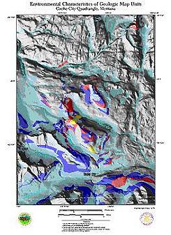
Figure 2. Environmental geology, New World Mining District. Cool colors indicate carbonate lithologies with net acid buffering capacity. Warm colors indicate net acid producing lithologies
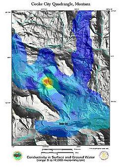
Figure 3. Conductivity in surface and ground water, New World Mining District. Warm colors indicate higher conductivity associated with historic mining disturbances in net acid producing areas
Naturally occurring sulfide mineralization contributed significantly to adverse impacts as well (Figure 8). However, geochemical and water quality data also suggested very strongly that, due to dilution and the dominant carbonate-based mineralization found in the immediate area (Figure 7, light blue), the proposed operations would not significantly impact water quality in the downstream environment (Miller and Gurrieri, 1997).
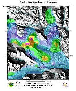
Figure 4. Surface and ground water pH, New World Mining District. Warm colors indicate acidic pH
Pursuant to the Montana Mined Land Reclamation Act and the National Environmental Policy Act, it was necessary to evaluate potential impacts to water quality as a result of mining ASARCO’s Rock Creek deposit.
Our approach used comparative modeling of the geology and hydrology of the Rock Creek deposit and a very similar silver deposit located nearby in Troy, Montana. The Troy Mine has been active during the past fifteen years. This study included an independent literature review of the past nine years of water quality data compiled for the Troy Mine. In addition, preliminary static and kinetic geochemical testing was conducted for both deposits.
Results suggested that the two deposits were geochemically and probably paragenetically comparable, and that potential water quality impacts associated with mining the Rock Creek deposit would be similar to water quality impacts currently associated with the Troy Mine (Miller, 1997). Adverse water quality impacts related to the Troy Mine were shown to be extremely limited, and probably a result of natural variation. Our work was instrumental in expediting the completion of the mine permitting process for the Rock Creek Project.
Canyon Resources had proposed mining a world class gold deposit located very near the Blackfoot River in Montana. Consequently, extreme scrutiny has been exercised by the operator, the regulating agencies, and interested environmental groups.
Peer review of the operator’s column leaching protocol was conducted and recommendations for modifications were given. As a result, this study has helped identify mitigation and alternative mining and reclamation plans that would lower the environmental risks associated with mining this world-class gold deposit.