|
|
We have used remote sensing, regional geologic reconnaissance mapping, geochemical analysis, and fluid inclusion techniques to identify exploration targets. GPS technology is available to download information in real time.
Remote sensing was conducted to explore for potential copper targets in southern Alaska (Figure 1). LandSat, magnetic, and geochemical information were used to highlight areas of gossan formation in mineralized areas of the Nabesna quadrangle. This project resulted in the discovery of three previously undetected porphyry copper targets.
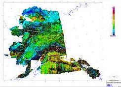
Figure 1. Alaska Statewide Magnetic Survey (USGS)
Regional reconnaissance mapping in a very remote area of southwest Chihuahua, Mexico identified widespread quartz-vein occurrences radial to a nearby Tertiary porphyry intrusion. To help confirm the intrusion as the mineralizing source, over 100 quartz vein samples were collected and assayed.
When mapped, Au/Ag metal ratios increased in a uniform manner through three orders of magnitude towards the intrusion. This study resulted in the identification of widespread, ore-grade, precious metals, epithermal, fissure-vein mineralization in the Llanitos Mining District (Miller and Goodell, 1988). Results provided strong indication that the intrusion was indeed the source of mineralization.
Later, oversight of bulk sampling and metallurgical testing was provided for the Llanitos District. Contracts with the Mexican government and the ASARCO smelter in El Paso were negotiated to complete the underground bulk-sampling project.